 vesseltracker.com
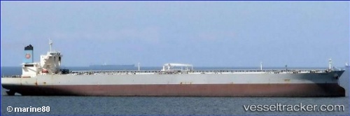
Vessel Pantanassa IMO: 9424261, MMSI: 249690000 Crude Oil Tanker
UTC, 20.42550, 62.86162, course: 320, speed: 7.6
UTC, 20.54767, 62.75511, course: 317, speed: 7.8
2026-01-18 14:29:39 UTC, 20.62954, 62.68293, course: 315, speed: 7.9
Live AIS position:
UTC. 211 nm SE of SUR),
updated 2026-01-18 14:29:39 UTC.
Find the position of the vessel Pantanassa on the map. The latter are known coordinates and path.
marine traffic ship tracker show on live map
The current position of vessel Pantanassa is 20.62954 lat / 62.68293 lng. Updated: 2026-01-18 14:29:39 UTCCurrently sailing under the flag of Malta
Pantanassa built in 2011 year
Deadweight:
317800 tDetails:
Last coordinates of the vessel:
UTC, 20.38599, 62.89692, course: 320, speed: 7.6UTC, 20.42550, 62.86162, course: 320, speed: 7.6
UTC, 20.54767, 62.75511, course: 317, speed: 7.8
2026-01-18 14:29:39 UTC, 20.62954, 62.68293, course: 315, speed: 7.9