.
vessel RONDO IMO: 8858013, General Cargo Ship vesseltracker.com
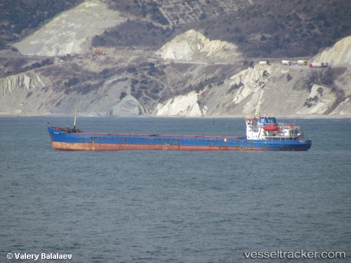
Vessel RONDO IMO: 8858013, MMSI: 511100642 General Cargo Ship

callsign: T8A3826
size: 15x108

Live AIS position: UTC. Near Iskenderun), updated 2024-09-20 11:41:18 UTC.

Find the position of the vessel RONDO on the map. The latter are known coordinates and path.

marine traffic ship tracker show on live map

The current position of vessel RONDO is 36.60313 lat / 36.16233 lng. Updated: 2024-09-20 11:41:18 UTC

Currently sailing under the flag of Palau (Republic of)

RONDO built in 1983 year

Deadweight:
3291 t

Details:


Last coordinates of the vessel:
2024-09-20 11:41:18 UTC, 36.60313, 36.16233, course: 339, speed: 6.5

Track of the vessel in the last 28 days


Most frequent ports a vessels calls at RONDO (511100642):

Uskudar, traffic: 22
Istanbul, traffic: 18
Gelibolu, traffic: 12
Kerch, traffic: 12
Rostov-Na-Donu, traffic: 9
Canakkale, traffic: 8
Rhodes, traffic: 8
Mersin, traffic: 4
Iskenderun, traffic: 1

Link to the map:


Find another ship

RONDO (511100642) last ports (portcalls and passsages)

Iskenderun | 2024-09-20 13:55:24
Uskudar | 2022-01-30 22:30:15
Rostov-Na-Donu | 2022-01-09 05:10:09
Kerch | 2022-01-02 14:40:02
Uskudar | 2021-12-30 12:30:25
Uskudar | 2021-12-30 10:25:06
Istanbul | 2021-12-30 09:35:15
Uskudar | 2021-12-29 22:50:09
Gelibolu | 2021-12-29 06:30:08
Canakkale | 2021-12-29 03:00:07
Rhodes | 2021-12-27 11:05:09
Mersin | 2021-12-24 04:40:15
Rhodes | 2021-12-21 11:40:05
Gelibolu | 2021-12-17 16:29:16
Kerch | 2021-12-13 09:00:09
Rostov-Na-Donu | 2021-12-08 19:40:12
Kerch | 2021-12-07 13:26:20
Uskudar | 2021-12-04 19:50:08
Uskudar | 2021-12-01 18:25:02
Gelibolu | 2021-12-01 03:15:58
Canakkale | 2021-12-01 00:25:08
Rostov-Na-Donu | 2021-09-30 16:11:25