 vesseltracker.com
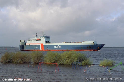
Vessel Saffet Bey IMO: 8417118, MMSI: 271000419 Ro Ro Cargo Ship
UTC, 25.90665, 55.89883, course: 179, speed: 0.9
UTC, 25.91049, 55.90834, course: 177, speed: 0
2026-01-17 11:04:25 UTC, 25.91327, 55.84765, course: 256, speed: 0
Live AIS position:
UTC. Near Hulaylah Terminal),
updated 2026-01-17 11:04:25 UTC.
Find the position of the vessel Saffet Bey on the map. The latter are known coordinates and path.
marine traffic ship tracker show on live map
The current position of vessel Saffet Bey is 25.91327 lat / 55.84765 lng. Updated: 2026-01-17 11:04:25 UTCCurrently sailing under the flag of Turkey
Saffet Bey built in 1987 year
Deadweight:
14107 tDetails:
Last coordinates of the vessel:
UTC, 25.83811, 55.93344, course: 164, speed: 0UTC, 25.90665, 55.89883, course: 179, speed: 0.9
UTC, 25.91049, 55.90834, course: 177, speed: 0
2026-01-17 11:04:25 UTC, 25.91327, 55.84765, course: 256, speed: 0