 vesseltracker.com
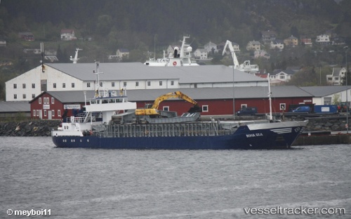
Vessel Bona Sea IMO: 8602012, MMSI: 258041000 Multi Purpose Carrier
UTC, 60.55304, 4.98545, course: 152, speed: 0
UTC, 60.55304, 4.98545, course: 152, speed: 0
2026-01-19 01:35:54 UTC, 60.55305, 4.98546, course: 153, speed: 0
Live AIS position:
UTC. Near Mjølkevikvarden),
updated 2026-01-19 01:35:54 UTC.
Find the position of the vessel Bona Sea on the map. The latter are known coordinates and path.
marine traffic ship tracker show on live map
The current position of vessel Bona Sea is 60.55305 lat / 4.98546 lng. Updated: 2026-01-19 01:35:54 UTCCurrently sailing under the flag of Norway
Bona Sea built in 1986 year
Deadweight:
1505 tDetails:
Last coordinates of the vessel:
UTC, 60.55303, 4.98544, course: 151, speed: 0UTC, 60.55304, 4.98545, course: 152, speed: 0
UTC, 60.55304, 4.98545, course: 152, speed: 0
2026-01-19 01:35:54 UTC, 60.55305, 4.98546, course: 153, speed: 0