 vesseltracker.com
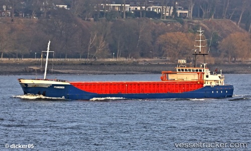
Vessel Francisca IMO: 9148166, MMSI: 212617000 Multi Purpose Carrier
UTC, 46.05011, -1.28488, course: 107, speed: 0.1
UTC, 46.04899, -1.28265, course: 324, speed: 0
2026-01-17 10:06:25 UTC, 46.04902, -1.28259, course: 320, speed: 0.1
Live AIS position:
UTC. Near Saint-Denis-d'Oléron),
updated 2026-01-17 10:06:25 UTC.
Find the position of the vessel Francisca on the map. The latter are known coordinates and path.
marine traffic ship tracker show on live map
The current position of vessel Francisca is 46.04902 lat / -1.28259 lng. Updated: 2026-01-17 10:06:25 UTCCurrently sailing under the flag of Cyprus
Francisca built in 1997 year
Deadweight:
3452 tDetails:
Last coordinates of the vessel:
UTC, 46.04833, -1.28333, course: -1, speed: 0UTC, 46.05011, -1.28488, course: 107, speed: 0.1
UTC, 46.04899, -1.28265, course: 324, speed: 0
2026-01-17 10:06:25 UTC, 46.04902, -1.28259, course: 320, speed: 0.1