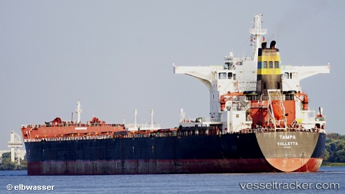
vessel Tampa IMO: 9363027, Bulk Carrier
Vessel Tampa IMO: 9363027, Bulk Carrier
MMSI: 256974000 callsign: 9HHA9 size: 45x292

Find the position of the vessel Tampa on the map. The latter are known coordinates and path.

marine traffic ship tracker show on live map

The current position of vessel Tampa is 54.5322 lat / 18.5519 lng. Updated: 2022-11-21 10:22:35 UTC
Port of registry:
Valletta (capital of Malta)
Payload_mass:
177987 tonne
Gross tonnage:
91373
Beam:
45.04 metre
Service entry:
2008-01-01T00:00:00Z

Manufacturer:
Shanghai Waigaoqiao Shipbuilding
Details:


Last coordinates of the vessel:
2022-11-21 10:22:35 UTC, 54.5322, 18.5519, course: 81, speed: 0


Most frequent ports a vessels calls at Tampa (256974000):

Sambu, traffic: 4
Selat Lombok, traffic: 3
Bur Ibrahim, traffic: 3
Port Hedland, traffic: 2
Vishakhapatnam, traffic: 2
Ra’S Shukhayr, traffic: 2
Port Headland, traffic: 2
Rio De Janeiro, traffic: 2
Port Elizabeth, traffic: 2
Singapore, traffic: 2
Skagens Odde, traffic: 2
Korsor, traffic: 1
Terneuzen, traffic: 1
Port Said, traffic: 1
Zeebrugge, traffic: 1

Link to the map:


Find another ship

Tampa (256974000) last ports (portcalls and passsages)

Gdynia | 2022-11-20 00:01:43
Terneuzen | 2022-11-13 17:45:21
Zeebrugge | 2022-11-13 15:03:41
Strait Of Gibraltar | 2022-11-07 08:20:23
Bur Ibrahim | 2022-10-30 05:16:39
Ra’S Shukhayr | 2022-10-29 01:55:53
Ra’S Shukhayr | 2022-08-06 04:23:09
Bur Ibrahim | 2022-08-05 16:49:48
Skagens Odde | 2022-07-20 22:53:59
Korsor | 2022-07-20 07:35:34
Ust-Luga | 2022-07-13 10:35:39
Skagens Odde | 2022-07-10 01:39:01
Port Said | 2022-06-25 19:53:59
Bur Ibrahim | 2022-06-25 07:34:21
Vishakhapatnam | 2022-06-05 04:11:53
Vishakhapatnam | 2022-06-01 04:11:30
Selat Lombok | 2022-04-15 03:31:23
Port Headland | 2022-04-09 18:20:13
Selat Lombok | 2022-04-04 17:28:11
Sambu | 2022-03-03 15:50:32
Singapore | 2022-03-03 15:10:03
Port Elizabeth | 2022-02-06 00:00:08
Rio De Janeiro | 2021-12-28 17:30:21