 vesseltracker.com
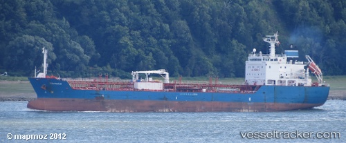
Vessel Tromso IMO: 9435791, MMSI: 311013300 Chemical Oil Products Tanker
UTC, 1.28579, 103.95879, course: 313, speed: 0
UTC, 1.26138, 103.95034, course: 209, speed: 9.5
2026-01-18 05:37:21 UTC, 1.17145, 103.79321, course: 247, speed: 9.5
Live AIS position:
UTC. Near BUKOM ISLAND),
updated 2026-01-18 05:37:21 UTC.
Find the position of the vessel Tromso on the map. The latter are known coordinates and path.
marine traffic ship tracker show on live map
The current position of vessel Tromso is 1.17145 lat / 103.79321 lng. Updated: 2026-01-18 05:37:21 UTCCurrently sailing under the flag of Bahamas
Tromso built in 2008 year
Deadweight:
12934 tDetails:
Last coordinates of the vessel:
UTC, 1.28530, 103.95768, course: 9, speed: 0UTC, 1.28579, 103.95879, course: 313, speed: 0
UTC, 1.26138, 103.95034, course: 209, speed: 9.5
2026-01-18 05:37:21 UTC, 1.17145, 103.79321, course: 247, speed: 9.5