 vesseltracker.com
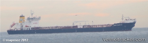
Vessel Dan Sabia IMO: 9513438, MMSI: 219333000 Crude Oil Tanker
UTC, 53.50833, 2.90500, course: -1, speed: 8
UTC, 52.81838, 2.65137, course: 182, speed: 10.8
2026-01-16 06:31:30 UTC, 52.65167, 2.64833, course: -1, speed: 11
Live AIS position:
UTC. 15 nm NW of Craven Arms),
updated 2026-01-16 06:31:30 UTC.
Find the position of the vessel Dan Sabia on the map. The latter are known coordinates and path.
marine traffic ship tracker show on live map
The current position of vessel Dan Sabia is 52.65167 lat / 2.64833 lng. Updated: 2026-01-16 06:31:30 UTCDetails:
Last coordinates of the vessel:
UTC, 53.69500, 3.01667, course: -1, speed: 8UTC, 53.50833, 2.90500, course: -1, speed: 8
UTC, 52.81838, 2.65137, course: 182, speed: 10.8
2026-01-16 06:31:30 UTC, 52.65167, 2.64833, course: -1, speed: 11