 vesseltracker.com
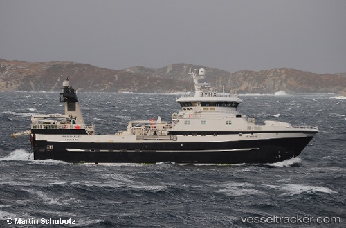
Vessel Prestfjord IMO: 9584566, MMSI: 257153500 Fishing Vessel
UTC, 74.54258, 16.23320, course: 348, speed: 6.7
UTC, 74.57872, 16.17348, course: 329, speed: 3.9
2026-01-18 05:52:17 UTC, 74.65167, 16.08000, course: -1, speed: 3
Live AIS position:
UTC. 51 nm W of Bjornoya),
updated 2026-01-18 05:52:17 UTC.
Find the position of the vessel Prestfjord on the map. The latter are known coordinates and path.
marine traffic ship tracker show on live map
The current position of vessel Prestfjord is 74.65167 lat / 16.08000 lng. Updated: 2026-01-18 05:52:17 UTCCurrently sailing under the flag of Norway
Prestfjord built in 2012 year
Deadweight:
1250 tDetails:
Last coordinates of the vessel:
UTC, 74.82000, 15.82833, course: -1, speed: 12UTC, 74.54258, 16.23320, course: 348, speed: 6.7
UTC, 74.57872, 16.17348, course: 329, speed: 3.9
2026-01-18 05:52:17 UTC, 74.65167, 16.08000, course: -1, speed: 3