 vesseltracker.com
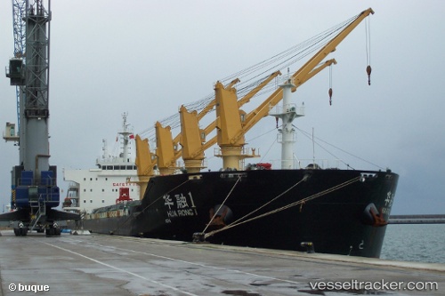
Vessel Hua Rong 1 IMO: 9650456, MMSI: 414119000 Bulk Carrier
UTC, 11.77167, 123.34833, course: -1, speed: 11
UTC, 11.77167, 123.34833, course: -1, speed: 11
2026-01-17 04:21:09 UTC, 11.72500, 123.53833, course: -1, speed: 11
Live AIS position:
UTC. 40 nm S of Masbate),
updated 2026-01-17 04:21:09 UTC.
Find the position of the vessel Hua Rong 1 on the map. The latter are known coordinates and path.
marine traffic ship tracker show on live map
The current position of vessel Hua Rong 1 is 11.72500 lat / 123.53833 lng. Updated: 2026-01-17 04:21:09 UTCCurrently sailing under the flag of China
Hua Rong 1 built in 2012 year
Deadweight:
56381 tDetails:
Last coordinates of the vessel:
UTC, 11.78500, 123.13833, course: -1, speed: 11UTC, 11.77167, 123.34833, course: -1, speed: 11
UTC, 11.77167, 123.34833, course: -1, speed: 11
2026-01-17 04:21:09 UTC, 11.72500, 123.53833, course: -1, speed: 11