.
vessel Maria Energy IMO: 9659725, Lng Tanker
vesseltracker.com
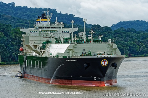
Vessel Maria Energy IMO: 9659725, MMSI: 636017445 Lng Tanker

callsign: D5KZ6
size: 46x289

Live AIS position: UTC. 134 nm NW of Kumejima), updated 2026-01-17 13:26:52 UTC.

Find the position of the vessel Maria Energy on the map. The latter are known coordinates and path.

marine traffic ship tracker show on live map

The current position of vessel Maria Energy is 28.41298 lat / 125.73554 lng. Updated: 2026-01-17 13:26:52 UTC
Details:


Last coordinates of the vessel:
UTC, 27.64870, 124.97416, course: 45, speed: 16.8
UTC, 27.77634, 125.10568, course: 45, speed: 17.3
UTC, 28.05261, 125.38416, course: 43, speed: 17.1
2026-01-17 13:26:52 UTC, 28.41298, 125.73554, course: 42, speed: 16.6


Most frequent ports a vessels calls at Maria Energy (636017445):

Kawasaki, traffic: 4
Yokohama, traffic: 4
BINTULU, traffic: 4
Singapore, traffic: 3
ONSLOW, traffic: 3
Strait Of Gibraltar, traffic: 3
BORYEONG, traffic: 3
Yokosuka, traffic: 3
ASHBURTON, traffic: 3
Sambu, traffic: 3
Bonny, traffic: 3
DAECHEONHANG, traffic: 3
Buenos Aires, traffic: 2
La Plata, traffic: 2
Calais, traffic: 2

Link to the map:


Find another ship

Maria_Energy (636017445) last ports (portcalls and passsages)

GOHYEON | 2025-08-31 04:35:01
ANJEONG | 2025-08-30 00:58:59
BUSAN NEW PORT | 2025-08-29 23:20:06
YANGSHAN | 2025-07-19 09:48:12
BINTULU | 2025-07-12 00:19:12
JURONG ISLAND | 2025-07-02 02:56:37
BUKOM ISLAND | 2025-07-02 00:55:34
TANAH MERAH | 2025-07-01 23:38:22
PENGERANG | 2025-07-01 22:04:07
Yokohama | 2025-06-20 19:58:56
ONSLOW | 2025-06-09 08:18:19
ASHBURTON | 2025-06-08 09:11:53
Selat Lombok | 2025-06-06 07:24:34
Barrow Island | 2025-05-18 15:28:28
Yokohama | 2025-05-08 04:58:27
KIMITSU | 2025-05-06 23:50:28
Yokosuka | 2025-05-06 22:59:31
ONSLOW | 2025-04-27 03:11:54
ASHBURTON | 2025-04-26 01:07:17
NAOETSU | 2025-04-13 23:43:21
ASHBURTON | 2025-03-30 08:31:28
BAKAUHENI | 2025-03-17 12:20:40
Map Ta Phut | 2025-03-11 22:54:54
BINTULU | 2025-03-04 00:09:36
DAECHEONHANG | 2025-02-19 03:19:15
BINTULU | 2025-02-07 01:22:33
BORYEONG | 2025-01-02 02:08:44
DAECHEONHANG | 2025-01-02 00:30:53
Tso-Ying | 2024-11-23 07:36:06
DAECHEONHANG | 2024-11-19 02:18:41
BINTULU | 2024-11-07 22:40:31
Sambu | 2024-11-03 09:59:11
Malabo | 2024-10-06 05:28:38
Singapore | 2024-09-15 04:10:46
Map Ta Phut | 2024-09-11 23:42:16
Yokohama | 2024-08-02 03:59:24
Yokosuka | 2024-08-01 00:56:54
Yokosuka | 2024-05-30 06:59:55
Yokohama | 2024-05-30 06:22:39
Kawasaki | 2024-05-30 06:15:13
Port Darwin | 2024-05-16 22:25:31
Cartagena | 2024-02-26 22:49:27
Strait Of Gibraltar | 2024-02-26 06:41:25
Sheerness | 2024-01-21 05:51:09
Bonny | 2023-12-29 03:25:31
Singapore | 2023-11-26 08:52:19
Bonny | 2023-10-30 01:37:42
Calais | 2023-09-16 06:35:58
La Plata | 2023-08-07 17:24:58
Buenos Aires | 2023-08-05 20:27:20
Salvador | 2023-07-25 09:16:26
La Plata | 2023-06-02 09:47:44
Buenos Aires | 2023-06-02 06:43:21
Milford Haven | 2023-04-21 15:08:03
Livorno | 2023-03-17 11:04:19
Livorno | 2023-03-13 09:01:18
Bonny | 2023-02-17 12:07:34
Algeciras | 2023-01-13 08:30:58
Galveston | 2022-09-02 14:00:53
Grand Banks South | 2022-08-26 04:09:10
Brixham | 2022-08-21 08:05:22
Strait Of Gibraltar | 2022-07-23 16:03:11
Cartagena | 2022-07-22 04:03:22
Port Said | 2022-07-13 16:07:55
Ras Gharib | 2022-06-23 22:37:55
Bur Ibrahim | 2022-06-23 16:52:05
Port Said | 2022-06-23 07:29:22
Canakkale | 2022-05-13 04:54:34
Strait Of Gibraltar | 2022-05-06 13:23:39
Gibraltar | 2022-05-02 12:42:38
Calais | 2022-03-24 06:25:07
Dover | 2021-12-31 21:50:14