.
vessel Patris IMO: 9766889, Lng Tanker
vesseltracker.com
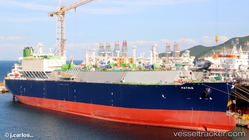
Vessel Patris IMO: 9766889, MMSI: 636018010 Lng Tanker

callsign: D5NT8
size: 295x46

Live AIS position: UTC. 16 nm SE of Kish Island), updated 2026-01-17 10:57:15 UTC.

Find the position of the vessel Patris on the map. The latter are known coordinates and path.

marine traffic ship tracker show on live map

The current position of vessel Patris is 26.34634 lat / 54.21176 lng. Updated: 2026-01-17 10:57:15 UTC

Currently sailing under the flag of Liberia

Details:


Last coordinates of the vessel:
UTC, 26.41468, 55.70298, course: 250, speed: 17.4
UTC, 26.32196, 54.89451, course: 276, speed: 18.8
UTC, 26.33923, 54.72704, course: 277, speed: 18.4
2026-01-17 10:57:15 UTC, 26.34634, 54.21176, course: 265, speed: 17.7


Most frequent ports a vessels calls at Patris (636018010):

Sambu, traffic: 22
Singapore, traffic: 13
BATU AMPAR, traffic: 4
TANAH MERAH, traffic: 4
Ponta Delgada, traffic: 4
Port Des Galets, traffic: 4
PULAU SAMBU, traffic: 4
Yokosuka, traffic: 3
Gladstone Harbor, traffic: 3
PENGERANG, traffic: 3
BUKOM ISLAND, traffic: 3
Algeciras, traffic: 2
Cochin, traffic: 2
Yokohama, traffic: 2
Map Ta Phut, traffic: 2

Link to the map:


Find another ship

Patris (636018010) last ports (portcalls and passsages)

Langsa Venture FPSO | 2025-09-15 13:10:01
PULAU SAMBU | 2025-08-17 08:09:02
BATU AMPAR | 2025-08-17 07:21:01
PENGERANG | 2025-08-17 06:05:42
YUNG AN | 2025-08-11 23:20:13
KIMITSU | 2025-07-19 23:48:01
Yokosuka | 2025-07-19 22:59:07
PENGERANG | 2025-07-12 20:40:55
TANAH MERAH | 2025-07-12 20:11:21
BATU AMPAR | 2025-07-12 19:21:27
JURONG ISLAND | 2025-06-13 05:21:58
BUKOM ISLAND | 2025-06-09 08:18:03
PULAU SAMBU | 2025-06-09 06:50:18
TANAH MERAH | 2025-06-09 05:22:53
PENGERANG | 2025-06-09 05:12:50
TANAH MERAH | 2025-05-12 23:51:53
BATU AMPAR | 2025-05-12 22:42:49
PULAU SAMBU | 2025-05-12 21:39:03
JURONG ISLAND | 2025-01-18 13:12:40
BUKOM ISLAND | 2025-01-18 11:29:51
PULAU SAMBU | 2025-01-18 11:01:25
BATU AMPAR | 2025-01-18 09:50:47
TANAH MERAH | 2025-01-18 09:07:54
GLADSTONE | 2024-12-28 01:47:55
GLADSTONE | 2024-11-29 01:57:33
Gladstone Harbor | 2024-11-01 15:23:37
Sambu | 2024-10-07 19:36:01
Port Des Galets | 2024-08-07 09:20:35
Singapore | 2024-07-28 20:54:55
Port Des Galets | 2024-07-04 04:13:25
Singapore | 2024-05-01 23:59:06
Sambu | 2024-05-01 23:17:43
Singapore | 2024-04-15 05:16:39
Port Des Galets | 2024-02-17 04:29:58
Singapore | 2024-02-07 10:38:20
Map Ta Phut | 2024-02-03 09:20:36
Sambu | 2024-02-01 03:40:00
Cochin | 2023-11-24 07:28:04
Singapore | 2023-10-18 03:23:27
Map Ta Phut | 2023-10-15 01:42:33
Sambu | 2023-10-12 07:22:33
Port Des Galets | 2023-10-01 07:39:22
Ponta Delgada | 2023-08-21 10:29:30
Cuxhaven | 2023-08-11 20:30:31
Ponta Delgada | 2023-08-03 09:52:40
Ponta Delgada | 2023-07-18 10:17:10
Strait Of Gibraltar | 2023-07-15 22:21:40
Algeciras | 2023-07-15 10:09:09
Strait Of Gibraltar | 2023-07-04 09:27:40
Ponta Delgada | 2023-05-22 18:01:35
Algeciras | 2023-05-19 22:48:14
Port Said | 2023-05-14 14:46:27
Cochin | 2023-04-24 01:53:10
Singapore | 2023-02-06 03:04:35
Singapore | 2022-10-06 07:26:57
Sambu | 2022-08-22 04:42:49
Torres Strait | 2022-07-27 23:35:31
Sambu | 2022-07-20 01:50:23
Singapore | 2022-07-16 01:56:42
Sambu | 2022-07-16 01:30:10
Sambu | 2022-03-22 09:30:46
Yokohama | 2022-03-14 02:41:49
Yokosuka | 2022-03-14 00:25:07
Singapore | 2022-02-14 06:05:39
Sambu | 2022-02-09 03:05:40