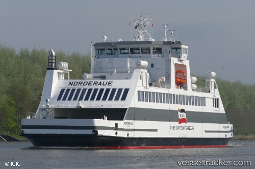
vessel Norderaue IMO: 9796121, Dredger
Vessel Norderaue IMO: 9796121, Dredger
MMSI: 211782080 callsign: DKIF2 size: 76x17

Find the position of the vessel Norderaue on the map. The latter are known coordinates and path.

marine traffic ship tracker show on live map

The current position of vessel Norderaue is 54.6932 lat / 8.5764 lng. Updated: 2024-11-01 14:50:16 UTC

Currently sailing under the flag of Germany

Port of registry:
Wyk auf Föhr (town in the Nordfriesland district, in Schleswig-Holstein, Germany)
Gross tonnage:
3250
Beam:
16.4 metre
Service entry:
2018-01-01T00:00:00Z

Manufacturer:
Neptun Werft (German shipbuilding company)


Owned:
Wyker Dampfschiffs-Reederei Föhr-Amrum (transport company)
Details:


Last coordinates of the vessel:
UTC, 54.7305, 8.68976, course: 287, speed: 0
UTC, 54.6932, 8.57634, course: 71, speed: 0
UTC, 54.6932, 8.5764, course: 71, speed: 0
2024-11-01 14:50:16 UTC, 54.6932, 8.5764, course: 71, speed: 0


Most frequent ports a vessels calls at Norderaue (211782080):

Esbjerg, traffic: 4

Link to the map:


Find another ship

Norderaue (211782080) last ports (portcalls and passsages)

Esbjerg | 2023-03-07 09:08:37
Esbjerg | 2023-03-03 08:05:31
Esbjerg | 2023-02-26 14:51:12
Esbjerg | 2022-03-13 15:29:46