 vesseltracker.com
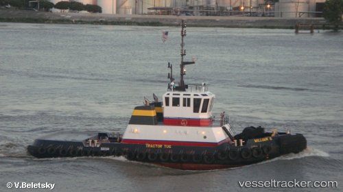
Vessel William S IMO: 1239737, MMSI: 367537450 Tug
UTC, 30.07461, -90.89984, course: 326, speed: 0
UTC, 30.07459, -90.89986, course: 327, speed: 0
2026-02-18 18:25:26 UTC, 30.08528, -90.91084, course: 16, speed: 1.6
Live AIS position:
UTC. Near Burnside),
updated 2026-02-18 18:25:26 UTC.
Find the position of the vessel William S on the map. The latter are known coordinates and path.
marine traffic ship tracker show on live map
The current position of vessel William S is 30.08528 lat / -90.91084 lng. Updated: 2026-02-18 18:25:26 UTCCurrently sailing under the flag of USA
Details:
Last coordinates of the vessel:
UTC, 30.07464, -90.89988, course: 329, speed: 0UTC, 30.07461, -90.89984, course: 326, speed: 0
UTC, 30.07459, -90.89986, course: 327, speed: 0
2026-02-18 18:25:26 UTC, 30.08528, -90.91084, course: 16, speed: 1.6