.
vessel CHEMTRANS TAURUS IMO: 9295036, Crude Oil Tanker vesseltracker.com
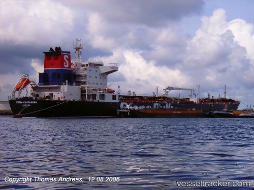
Vessel CHEMTRANS TAURUS IMO: 9295036, MMSI: 210132000 Crude Oil Tanker

callsign: 5BRK5
size: 32x227

Live AIS position: UTC. Near Belle Chase), updated 2023-05-16 20:05:42 UTC.

Find the position of the vessel CHEMTRANS TAURUS on the map. The latter are known coordinates and path.

marine traffic ship tracker show on live map

The current position of vessel CHEMTRANS TAURUS is 29.83728 lat / -89.99425 lng. Updated: 2023-05-16 20:05:42 UTC

Currently sailing under the flag of Cyprus

CHEMTRANS TAURUS built in 2006 year

Deadweight:
72782 t

Details:


Last coordinates of the vessel:
2023-05-16 20:05:42 UTC, 29.83728, -89.99425, course: 37, speed: 0.1


Most frequent ports a vessels calls at CHEMTRANS TAURUS (210132000):

Port Royal, traffic: 2
Kingston, traffic: 2
Tompkinsville, traffic: 2
Bayonne, traffic: 2
Brooklyn, traffic: 2
Ostrica, traffic: 1
Deepwater Point, traffic: 1
Port Newark, traffic: 1
Jersey City, traffic: 1
Salvador, traffic: 1
La Plata, traffic: 1
Marcus Hook, traffic: 1
Myrtle Grove, traffic: 1
Atucha, traffic: 1
New Orleans, traffic: 1

Link to the map:


Find another ship

CHEMTRANS_TAURUS (210132000) last ports (portcalls and passsages)

New Orleans | 2023-05-09 23:38:58
Myrtle Grove | 2023-05-06 20:26:04
Ostrica | 2023-05-06 17:26:16
Coatzacoalcos | 2023-05-01 23:41:35
Port Royal | 2023-04-15 19:22:02
Port Royal | 2023-04-11 18:55:54
Oranjestad | 2023-03-31 14:08:23
Tompkinsville | 2023-03-26 10:13:09
Tompkinsville | 2023-03-22 08:11:09
Marcus Hook | 2023-03-19 18:05:20
Deepwater Point | 2023-03-19 15:00:12
La Plata | 2023-02-06 20:41:34
Buenos Aires | 2023-02-03 17:43:37
Salvador | 2023-01-23 05:39:28