 vesseltracker.com
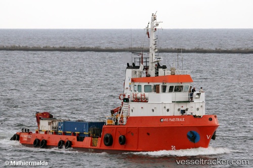
Vessel LEDRA EXPLORER IMO: 8204781, MMSI: 210330000 Offshore Supply Ship
UTC, 36.65785, 22.51149, course: 53, speed: 0.1
UTC, 36.65795, 22.51142, course: 21, speed: 0
2026-02-22 06:52:09 UTC, 36.65800, 22.51137, course: 31, speed: 0.1
Live AIS position:
UTC. Near Areópolis),
updated 2026-02-22 06:52:09 UTC.
Find the position of the vessel LEDRA EXPLORER on the map. The latter are known coordinates and path.
marine traffic ship tracker show on live map
The current position of vessel LEDRA EXPLORER is 36.65800 lat / 22.51137 lng. Updated: 2026-02-22 06:52:09 UTCCurrently sailing under the flag of Cyprus
LEDRA EXPLORER built in 1984 year
Deadweight:
376 tDetails:
Last coordinates of the vessel:
UTC, 36.65785, 22.51149, course: 53, speed: 0.1UTC, 36.65785, 22.51149, course: 53, speed: 0.1
UTC, 36.65795, 22.51142, course: 21, speed: 0
2026-02-22 06:52:09 UTC, 36.65800, 22.51137, course: 31, speed: 0.1