 vesseltracker.com
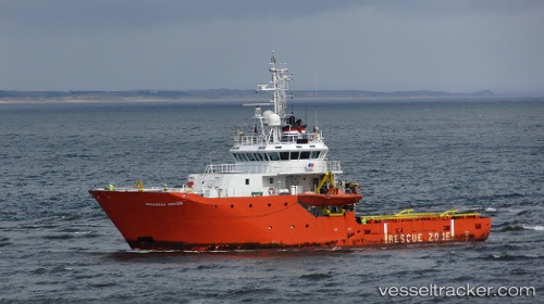
Vessel Grampian Ranger IMO: 9235311, MMSI: 235477000 Standby Safety Vessel
UTC, 57.13567, -2.05100, course: 260, speed: 0.1
UTC, 57.14133, -1.84267, course: 82, speed: 4
2026-02-03 02:10:22 UTC, 57.14233, -1.62167, course: 87, speed: 4
Live AIS position:
UTC. 15 nm E of Cove (Aberdeen)),
updated 2026-02-03 02:10:22 UTC.
Find the position of the vessel Grampian Ranger on the map. The latter are known coordinates and path.
marine traffic ship tracker show on live map
The current position of vessel Grampian Ranger is 57.14233 lat / -1.62167 lng. Updated: 2026-02-03 02:10:22 UTCCurrently sailing under the flag of United Kingdom
Grampian Ranger built in 2002 year
Deadweight:
300 tDetails:
Last coordinates of the vessel:
UTC, 57.13567, -2.05100, course: 259, speed: 0UTC, 57.13567, -2.05100, course: 260, speed: 0.1
UTC, 57.14133, -1.84267, course: 82, speed: 4
2026-02-03 02:10:22 UTC, 57.14233, -1.62167, course: 87, speed: 4