 vesseltracker.com
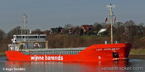
Vessel Lady Anne Beau IMO: 9760407, MMSI: 244890901 General Cargo Ship
UTC, 53.55816, 0.10516, course: 129, speed: 9.3
UTC, 53.44562, 0.40862, course: 138, speed: 6.7
2026-02-10 05:33:54 UTC, 53.30333, 0.62167, course: -1, speed: 7
Live AIS position:
UTC. 12 nm NE of Chapel Saint Leonards),
updated 2026-02-10 05:33:54 UTC.
Find the position of the vessel Lady Anne Beau on the map. The latter are known coordinates and path.
marine traffic ship tracker show on live map
The current position of vessel Lady Anne Beau is 53.30333 lat / 0.62167 lng. Updated: 2026-02-10 05:33:54 UTCCurrently sailing under the flag of Netherlands
Details:
Last coordinates of the vessel:
UTC, 53.72465, -0.25887, course: 111, speed: 11.6UTC, 53.55816, 0.10516, course: 129, speed: 9.3
UTC, 53.44562, 0.40862, course: 138, speed: 6.7
2026-02-10 05:33:54 UTC, 53.30333, 0.62167, course: -1, speed: 7