.
vessel Volgo balt 195 IMO: 8865999, General Cargo Ship
vesseltracker.com
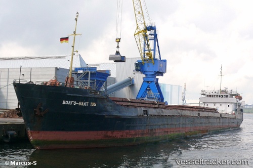
Vessel Volgo balt 195 IMO: 8865999, MMSI: 273332400 General Cargo Ship

callsign: UEHD
size: 114x13

Live AIS position: UTC. 19 nm S of Taman'), updated 2026-02-11 01:27:46 UTC.

Find the position of the vessel Volgo balt 195 on the map. The latter are known coordinates and path.

marine traffic ship tracker show on live map

The current position of vessel Volgo balt 195 is 44.91734 lat / 36.56378 lng. Updated: 2026-02-11 01:27:46 UTC

Currently sailing under the flag of Russia

Volgo balt 195 built in 1976 year

Deadweight:
3180 t

Details:


Last coordinates of the vessel:
UTC, 45.06397, 36.59667, course: 60, speed: 11.1
UTC, 44.91723, 36.56337, course: 72, speed: 1.1
UTC, 45.06003, 36.60037, course: 71, speed: 35
2026-02-11 01:27:46 UTC, 44.91734, 36.56378, course: 71, speed: 2.4


Most frequent ports a vessels calls at Volgo balt 195 (273332400):

Warnemunde, traffic: 28
Helsingor, traffic: 20
Rostock, traffic: 16
Kobenhavn, traffic: 8
Land Skrona, traffic: 8
Slite, traffic: 8
Copenhagen, traffic: 8
Halsingborg, traffic: 8
Helsingborg, traffic: 8
Randers, traffic: 4
Wismar, traffic: 4
Kaliningrad, traffic: 2
Sankt-Peterburg, traffic: 1

Link to the map:


Find another ship

Volgo_balt_195 (273332400) last ports (portcalls and passsages)

Sankt-Peterburg | 2022-05-02 12:21:40
Kaliningrad | 2022-03-01 03:25:11
Warnemunde | 2022-02-23 12:15:45
Warnemunde | 2022-02-09 15:05:08
Warnemunde | 2022-02-08 03:20:22
Slite | 2022-01-29 16:30:30
Warnemunde | 2022-01-25 01:30:36
Slite | 2022-01-13 13:40:30
Warnemunde | 2022-01-11 20:05:00
Warnemunde | 2022-01-10 10:55:39
Warnemunde | 2022-01-10 09:50:10
Kobenhavn | 2021-12-31 01:25:14
Land Skrona | 2021-12-31 00:45:04
Helsingor | 2021-12-31 00:00:24
Helsingor | 2021-12-30 22:55:14
Helsingor | 2021-12-30 22:45:14
Randers | 2021-12-28 10:10:06
Helsingor | 2021-12-27 18:25:13
Helsingor | 2021-12-27 17:40:54
Land Skrona | 2021-12-27 16:11:03
Kobenhavn | 2021-12-27 15:00:34
Wismar | 2021-12-01 00:00:51