 vesseltracker.com
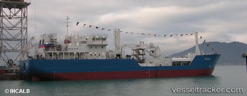
Vessel Rossita IMO: 9531894, MMSI: 273357130 Nuclear Fuel Carrier
UTC, 69.04833, 33.07167, course: -1, speed: -0.1
UTC, 69.04833, 33.07167, course: -1, speed: -0.1
2026-02-20 09:35:17 UTC, 69.04833, 33.07167, course: -1, speed: -0.1
Live AIS position:
UTC. Near Murmansk),
updated 2026-02-20 09:35:17 UTC.
Find the position of the vessel Rossita on the map. The latter are known coordinates and path.
marine traffic ship tracker show on live map
The current position of vessel Rossita is 69.04833 lat / 33.07167 lng. Updated: 2026-02-20 09:35:17 UTCDetails:
Last coordinates of the vessel:
UTC, 69.04833, 33.07167, course: -1, speed: 0UTC, 69.04833, 33.07167, course: -1, speed: -0.1
UTC, 69.04833, 33.07167, course: -1, speed: -0.1
2026-02-20 09:35:17 UTC, 69.04833, 33.07167, course: -1, speed: -0.1