 vesseltracker.com
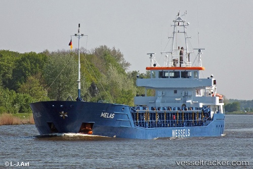
Vessel Melas IMO: 9409625, MMSI: 305813000 Multi Purpose Carrier
UTC, 57.57957, 17.69939, course: 180, speed: 11.2
UTC, 57.03084, 17.70775, course: 174, speed: 11.2
2026-02-14 08:23:33 UTC, 56.67541, 17.77496, course: 169, speed: 11.1
Live AIS position:
UTC. 33 nm SE of Kårehamn),
updated 2026-02-14 08:23:33 UTC.
Find the position of the vessel Melas on the map. The latter are known coordinates and path.
marine traffic ship tracker show on live map
The current position of vessel Melas is 56.67541 lat / 17.77496 lng. Updated: 2026-02-14 08:23:33 UTCCurrently sailing under the flag of Antigua Barbuda
Melas built in 2010 year
Deadweight:
3675 tDetails:
Last coordinates of the vessel:
UTC, 57.83131, 17.71125, course: 184, speed: 11.1UTC, 57.57957, 17.69939, course: 180, speed: 11.2
UTC, 57.03084, 17.70775, course: 174, speed: 11.2
2026-02-14 08:23:33 UTC, 56.67541, 17.77496, course: 169, speed: 11.1