 vesseltracker.com
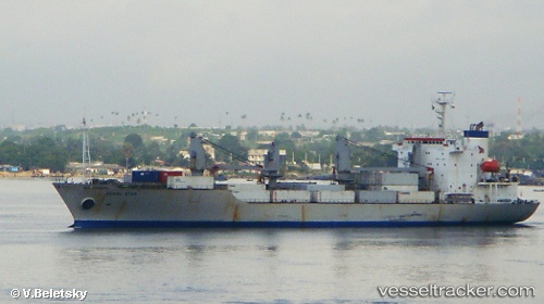
Vessel Regal Bay IMO: 9053658, MMSI: 311907000 Refrigerated Cargo Ship
UTC, 18.83333, -74.60500, course: -1, speed: 13
UTC, 19.15667, -74.43167, course: -1, speed: 12
2026-02-24 16:27:11 UTC, 19.62833, -74.17333, course: -1, speed: 13
Live AIS position:
UTC. 37 nm S of Punta de Maisi),
updated 2026-02-24 16:27:11 UTC.
Find the position of the vessel Regal Bay on the map. The latter are known coordinates and path.
marine traffic ship tracker show on live map
The current position of vessel Regal Bay is 19.62833 lat / -74.17333 lng. Updated: 2026-02-24 16:27:11 UTCCurrently sailing under the flag of Bahamas
Regal Bay built in 1993 year
Deadweight:
10520 tDetails:
Last coordinates of the vessel:
UTC, 18.33167, -74.82667, course: -1, speed: 14UTC, 18.83333, -74.60500, course: -1, speed: 13
UTC, 19.15667, -74.43167, course: -1, speed: 12
2026-02-24 16:27:11 UTC, 19.62833, -74.17333, course: -1, speed: 13