 vesseltracker.com
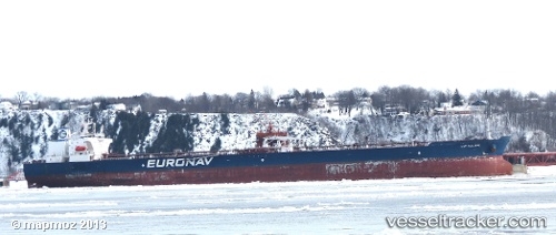
Vessel IKARA IMO: 9321718, MMSI: 352001929 Crude Oil Tanker
Live AIS position:
UTC. 119 nm W of Rota-Izmit Bay),
updated 2025-10-24 19:03:38 UTC.
Find the position of the vessel IKARA on the map. The latter are known coordinates and path.
marine traffic ship tracker show on live map
The current position of vessel IKARA is 29.35558 lat / 38.52087 lng. Updated: 2025-10-24 19:03:38 UTCCurrently sailing under the flag of Panama
IKARA built in 2006 year
Deadweight:
158920 tDetails:
Last coordinates of the vessel:
2025-10-24 19:03:38 UTC, 29.35558, 38.52087, course: 236, speed: 2.4