 vesseltracker.com
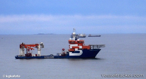
Vessel FU TAI IMO: 9382217, MMSI: 352986181 Cable-Layer
UTC, 31.04167, 121.47500, course: -1, speed: 0
UTC, 31.04250, 121.47617, course: 354, speed: 0
2026-02-26 09:35:56 UTC, 31.04250, 121.47617, course: 354, speed: 0
Live AIS position:
UTC. Near Minhang),
updated 2026-02-26 09:35:56 UTC.
Find the position of the vessel FU TAI on the map. The latter are known coordinates and path.
marine traffic ship tracker show on live map
The current position of vessel FU TAI is 31.04250 lat / 121.47617 lng. Updated: 2026-02-26 09:35:56 UTCCurrently sailing under the flag of Panama
FU TAI built in 2007 year
Deadweight:
7000 tDetails:
Last coordinates of the vessel:
UTC, 31.04250, 121.47617, course: 354, speed: 0.1UTC, 31.04167, 121.47500, course: -1, speed: 0
UTC, 31.04250, 121.47617, course: 354, speed: 0
2026-02-26 09:35:56 UTC, 31.04250, 121.47617, course: 354, speed: 0