 vesseltracker.com
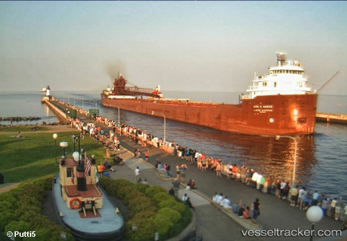
Vessel Kaye E Barker IMO: 5097450, MMSI: 366904910 Self Discharging Bulk Carrier
UTC, 46.87859, -85.98469, course: 269, speed: 9.6
UTC, 46.88064, -86.49287, course: 268, speed: 9.4
2026-01-05 08:38:58 UTC, 46.82281, -86.68220, course: 238, speed: 9.1
Live AIS position:
UTC. 23 nm N of Christmas),
updated 2026-01-05 08:38:58 UTC.
Find the position of the vessel Kaye E Barker on the map. The latter are known coordinates and path.
marine traffic ship tracker show on live map
The current position of vessel Kaye E Barker is 46.82281 lat / -86.68220 lng. Updated: 2026-01-05 08:38:58 UTCCurrently sailing under the flag of USA
Kaye E Barker built in 1952 year
Deadweight:
25345 tDetails:
Last coordinates of the vessel:
UTC, 46.87850, -85.92351, course: 269, speed: 9.5UTC, 46.87859, -85.98469, course: 269, speed: 9.6
UTC, 46.88064, -86.49287, course: 268, speed: 9.4
2026-01-05 08:38:58 UTC, 46.82281, -86.68220, course: 238, speed: 9.1