 vesseltracker.com
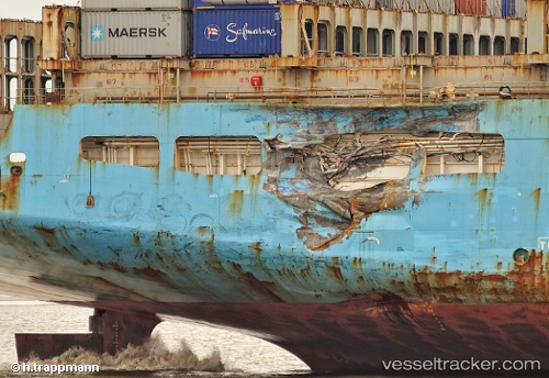
Vessel MAERSK KALMAR IMO: 9153862, MMSI: 636020350 Container Ship
UTC, 25.01198, 54.38405, course: -1, speed: 45.7
UTC, 25.01198, 54.38405, course: -1, speed: 45.7
2026-03-04 03:38:21 UTC, 25.01198, 54.38405, course: -1, speed: 45.7
Live Vessel MAERSK KALMAR Analytics (details, animations, etc.)
Live AIS position: UTC. 19 nm NW of Mina Khalifa/Abu Dhabi), updated 2026-03-04 03:38:21 UTC.Find the position of the vessel MAERSK KALMAR on the map. The latter are known coordinates and path.
marine traffic ship tracker show on live map
The current position of vessel MAERSK KALMAR is 25.01198 lat / 54.38405 lng. Updated: 2026-03-04 03:38:21 UTCCurrently sailing under the flag of Liberia
MAERSK KALMAR built in 1998 year
Deadweight:
94769 tDetails:
Last coordinates of the vessel:
UTC, 25.01198, 54.38405, course: -1, speed: 45.7UTC, 25.01198, 54.38405, course: -1, speed: 45.7
UTC, 25.01198, 54.38405, course: -1, speed: 45.7
2026-03-04 03:38:21 UTC, 25.01198, 54.38405, course: -1, speed: 45.7