 vesseltracker.com
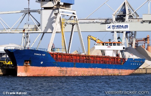
Vessel Danica Hav IMO: 8401535, MMSI: 308924000 Multi Purpose Carrier
UTC, 54.51522, 6.62265, course: 296, speed: 7.6
UTC, 54.57263, 6.32427, course: 281, speed: 7
2026-03-14 17:50:31 UTC, 54.62833, 5.83167, course: -1, speed: 7
Live Vessel Danica Hav Analytics (details, animations, etc.)
Live AIS position: UTC. 58 nm N of Town Quays/Drogheda), updated 2026-03-14 17:50:31 UTC.Find the position of the vessel Danica Hav on the map. The latter are known coordinates and path.
marine traffic ship tracker show on live map
The current position of vessel Danica Hav is 54.62833 lat / 5.83167 lng. Updated: 2026-03-14 17:50:31 UTCCurrently sailing under the flag of Bahamas
Danica Hav built in 1984 year
Deadweight:
1720 tDetails:
Last coordinates of the vessel:
UTC, 54.36333, 7.04167, course: -1, speed: 7UTC, 54.51522, 6.62265, course: 296, speed: 7.6
UTC, 54.57263, 6.32427, course: 281, speed: 7
2026-03-14 17:50:31 UTC, 54.62833, 5.83167, course: -1, speed: 7