 vesseltracker.com
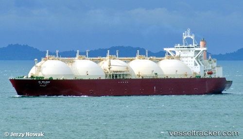
Vessel AL WAJBAH IMO: 9085625, MMSI: 538009769 LNG Tanker
UTC, 11.78891, 112.34780, course: -1, speed: 14.1
UTC, 11.42266, 112.08374, course: -1, speed: 14.1
2026-02-27 10:14:56 UTC, 10.89980, 111.72304, course: -1, speed: 13.8
Live AIS position:
UTC. 163 nm E of Vinh Cam Ranh),
updated 2026-02-27 10:14:56 UTC.
Find the position of the vessel AL WAJBAH on the map. The latter are known coordinates and path.
marine traffic ship tracker show on live map
The current position of vessel AL WAJBAH is 10.89980 lat / 111.72304 lng. Updated: 2026-02-27 10:14:56 UTCCurrently sailing under the flag of Marshall Islands
AL WAJBAH built in 1997 year
Deadweight:
72348 tDetails:
Last coordinates of the vessel:
UTC, 12.14602, 112.61555, course: -1, speed: 14.6UTC, 11.78891, 112.34780, course: -1, speed: 14.1
UTC, 11.42266, 112.08374, course: -1, speed: 14.1
2026-02-27 10:14:56 UTC, 10.89980, 111.72304, course: -1, speed: 13.8