 vesseltracker.com
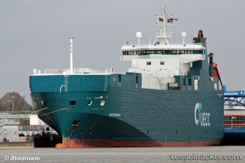
Vessel FINO IMO: 9131943, MMSI: 636021411 Vehicles Carrier
UTC, -42.47349, -176.26100, course: 161, speed: 51
UTC, -42.47349, -176.26100, course: 161, speed: 51
UTC, -29.98690, 82.66669, course: 13, speed: 67.2
UTC, 51.96191, 1.29164, course: 305, speed: 0
2026-02-25 14:15:17 UTC, 51.96191, 1.29164, course: 305, speed: 0
Live AIS position:
UTC. Near SHOTLEY),
updated 2026-02-25 14:15:17 UTC.
Find the position of the vessel FINO on the map. The latter are known coordinates and path.
marine traffic ship tracker show on live map
The current position of vessel FINO is 51.96191 lat / 1.29164 lng. Updated: 2026-02-25 14:15:17 UTCCurrently sailing under the flag of Liberia
FINO built in 1997 year
Deadweight:
4443 tDetails:
Last coordinates of the vessel:
UTC, -42.47349, -176.26100, course: 161, speed: 51UTC, -42.47349, -176.26100, course: 161, speed: 51
UTC, -42.47349, -176.26100, course: 161, speed: 51
UTC, -29.98690, 82.66669, course: 13, speed: 67.2
UTC, 51.96191, 1.29164, course: 305, speed: 0
2026-02-25 14:15:17 UTC, 51.96191, 1.29164, course: 305, speed: 0