 vesseltracker.com
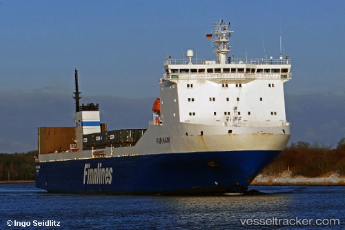
Vessel BAHIA CARGO IMO: 9207895, MMSI: 224787000 Ro-Ro Cargo
UTC, 28.67596, -17.76844, course: 173, speed: 0
UTC, 28.67596, -17.76844, course: 173, speed: 0
2026-02-28 23:06:57 UTC, 28.67596, -17.76844, course: 172, speed: 0
Live AIS position:
UTC. Near Santa Cruz de La Palma),
updated 2026-02-28 23:06:57 UTC.
Find the position of the vessel BAHIA CARGO on the map. The latter are known coordinates and path.
marine traffic ship tracker show on live map
The current position of vessel BAHIA CARGO is 28.67596 lat / -17.76844 lng. Updated: 2026-02-28 23:06:57 UTCCurrently sailing under the flag of Spain
Details:
Last coordinates of the vessel:
UTC, 28.67596, -17.76844, course: 173, speed: 0UTC, 28.67596, -17.76844, course: 173, speed: 0
UTC, 28.67596, -17.76844, course: 173, speed: 0
2026-02-28 23:06:57 UTC, 28.67596, -17.76844, course: 172, speed: 0