.
vessel Sarak IMO: 9226968, Crude Oil Tanker
vesseltracker.com
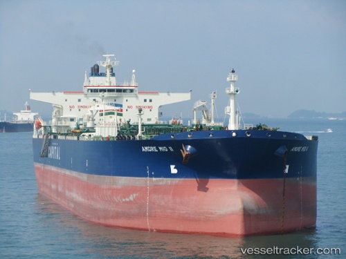
Vessel Sarak IMO: 9226968, MMSI: 422160400 Crude Oil Tanker

callsign: A8MF6
size: 48x273

Live AIS position: UTC. Near Offshore Fujairah), updated 2026-02-20 14:55:35 UTC.

Find the position of the vessel Sarak on the map. The latter are known coordinates and path.

marine traffic ship tracker show on live map

The current position of vessel Sarak is 25.38305 lat / 56.70207 lng. Updated: 2026-02-20 14:55:35 UTC
Details:


Last coordinates of the vessel:
UTC, 25.42488, 56.57097, course: 64, speed: 5.8
UTC, 25.38305, 56.70207, course: 120, speed: 7.5
2026-02-20 14:55:35 UTC, 25.38305, 56.70207, course: 120, speed: 7.5


Most frequent ports a vessels calls at Sarak (422160400):

Sambu, traffic: 11
Singapore, traffic: 9
BATU AMPAR, traffic: 6
PENGERANG, traffic: 5
PULAU SAMBU, traffic: 5
TANAH MERAH, traffic: 5
Nantong, traffic: 2
JURONG ISLAND, traffic: 2
BUKOM ISLAND, traffic: 2

Link to the map:


Find another ship

Sarak (422160400) last ports (portcalls and passsages)

JURONG ISLAND | 2025-07-23 20:47:58
PULAU SAMBU | 2025-07-23 18:45:31
BATU AMPAR | 2025-07-23 17:31:26
PENGERANG | 2025-07-23 14:42:02
PENGERANG | 2025-05-31 20:48:14
TANAH MERAH | 2025-05-31 19:41:43
PULAU SAMBU | 2025-05-31 18:30:24
BUKOM ISLAND | 2025-05-31 18:04:13
BUKOM ISLAND | 2025-04-07 03:22:32
Singapore | 2025-04-07 02:21:16
BATU AMPAR | 2025-04-07 01:55:29
TANAH MERAH | 2025-04-07 00:48:21
PENGERANG | 2025-04-06 23:45:50
TANAH MERAH | 2025-03-30 23:04:26
PULAU SAMBU | 2025-03-30 22:07:28
JURONG ISLAND | 2025-01-15 14:35:35
PULAU SAMBU | 2025-01-15 13:12:44
TANAH MERAH | 2025-01-15 12:12:14
PENGERANG | 2025-01-15 10:32:56
PENGERANG | 2024-12-31 03:42:28
TANAH MERAH | 2024-12-31 02:45:04
Singapore | 2024-09-10 20:20:40
Nantong | 2024-05-23 08:17:47
Nantong | 2024-04-13 14:26:59
Singapore | 2024-03-06 21:40:11
Singapore | 2023-12-06 16:28:18
Sambu | 2023-08-27 04:56:25
Sambu | 2023-06-18 20:17:21
Singapore | 2023-05-21 21:28:32