.
vessel 'OCEAN PILGRIM' IMO: 9254458, vesseltracker.com
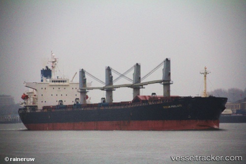
Vessel 'OCEAN PILGRIM' IMO: 9254458, MMSI: 355287000

callsign:
size: x

Live AIS position: UTC. Near Bayuquan), updated 2026-02-17 05:48:57 UTC.

Find the position of the vessel 'OCEAN PILGRIM' on the map. The latter are known coordinates and path.

marine traffic ship tracker show on live map

The current position of vessel 'OCEAN PILGRIM' is 40.24725 lat / 122.08452 lng. Updated: 2026-02-17 05:48:57 UTC
Details:


Last coordinates of the vessel:
UTC, 40.24715, 122.08445, course: 271, speed: 0.1
UTC, 40.24707, 122.08452, course: 271, speed: 0
UTC, 40.24710, 122.08445, course: 271, speed: 0
2026-02-17 05:48:57 UTC, 40.24725, 122.08452, course: 271, speed: 0.2


Most frequent ports a vessels calls at 'OCEAN PILGRIM' (355287000):

Taku Bar, traffic: 4
Dagu Bar, traffic: 4
Ta-Ku, traffic: 2
Tanjung Priok, traffic: 2
Dagu, traffic: 2
Hong Kong, traffic: 2
Jakarta, traffic: 2
Tai-tung Kang, traffic: 2
Port Swettenham, traffic: 1
Wu-Sung, traffic: 1
Wusong, traffic: 1
Hsia-Men, traffic: 1
Xiamen, traffic: 1
Kao-Hsiung Kang, traffic: 1
Taicang, traffic: 1

Link to the map:


Find another ship

'OCEAN_PILGRIM' (355287000) last ports (portcalls and passsages)

Taicang | 2024-01-09 08:01:31
Wusong | 2024-01-09 05:23:31
Jingjiang | 2024-01-09 00:19:53
Xiamen | 2022-11-25 02:37:03
Tai-tung Kang | 2022-10-27 05:05:30
Tai-tung Kang | 2022-10-23 04:58:44
Kao-Hsiung Kang | 2022-10-20 13:12:48
Lianyungang | 2022-09-20 10:53:22
Hong Kong | 2022-08-15 04:07:40
Hong Kong | 2022-07-25 07:22:11
Tanjung Priok | 2022-05-16 22:16:48
Tanjung Priok | 2022-05-12 19:25:47
Port Swettenham | 2022-02-27 06:17:46
Dagu Bar | 2022-02-16 03:04:48
Ta-Ku | 2022-01-22 12:31:20
Taku Bar | 2022-01-03 09:22:43
Taku Bar | 2022-01-03 08:34:51