.
vessel IVI IMO: 9268394, LPG Tanker vesseltracker.com
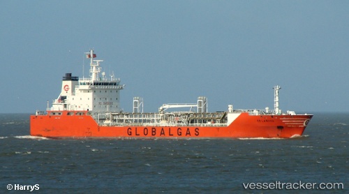
Vessel IVI IMO: 9268394, MMSI: 636021554 LPG Tanker

callsign: 5LEN4
size: x

Live AIS position: UTC. 37 nm SE of Macaé), updated 2026-01-30 20:24:49 UTC.

Find the position of the vessel IVI on the map. The latter are known coordinates and path.

marine traffic ship tracker show on live map

The current position of vessel IVI is -22.64277 lat / -41.17243 lng. Updated: 2026-01-30 20:24:49 UTC

Currently sailing under the flag of Liberia

IVI built in 2003 year

Deadweight:
7496 t

Details:


Last coordinates of the vessel:
UTC, -23.44137, -42.02235, course: 46, speed: 10.1
UTC, -23.16500, -41.69333, course: -1, speed: 10
UTC, -23.01500, -41.54667, course: -1, speed: 10
2026-01-30 20:24:49 UTC, -22.64277, -41.17243, course: 46, speed: 10.5


Most frequent ports a vessels calls at IVI (636021554):

Piraeus, traffic: 12
Uskudar, traffic: 8
Salamis, traffic: 8
Canakkale, traffic: 4
Gelibolu, traffic: 4
Istanbul, traffic: 4
Arzew, traffic: 4
Skaramangas, traffic: 4
Freeport, traffic: 2
Kerch, traffic: 2
Agadir, traffic: 2
Algeciras, traffic: 2
Siracusa, traffic: 2
Augusta, traffic: 2
Strait Of Gibraltar, traffic: 2

Link to the map:


Find another ship

IVI (636021554) last ports (portcalls and passsages)

Durres | 2022-02-17 21:55:07
Arzew | 2022-02-13 14:38:26
Augusta | 2022-02-08 12:25:12
Siracusa | 2022-02-08 08:50:43
Arzew | 2022-02-02 14:18:40
Skaramangas | 2022-01-24 06:40:26
Salamis | 2022-01-24 06:06:10
Skaramangas | 2022-01-24 05:55:34
Salamis | 2022-01-24 05:50:23
Piraeus | 2022-01-24 05:45:23
Piraeus | 2022-01-24 05:40:23
Canakkale | 2022-01-23 12:40:01
Gelibolu | 2022-01-23 10:52:03
Uskudar | 2022-01-22 21:05:05
Uskudar | 2022-01-22 20:55:00
Kerch | 2022-01-08 00:30:07
Uskudar | 2022-01-05 12:30:10
Uskudar | 2022-01-05 11:40:03
Gelibolu | 2022-01-04 15:23:32
Canakkale | 2022-01-04 13:15:02
Algeciras | 2021-12-25 21:20:08
Strait Of Gibraltar | 2021-12-25 19:20:01
Agadir | 2021-12-21 09:10:30
Freeport | 2021-12-01 00:07:02