 vesseltracker.com
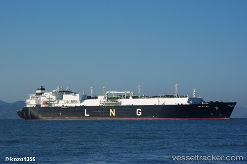
Vessel OB RIVER IMO: 9315692, MMSI: 538002846 LNG Tanker
UTC, 1.31625, 104.23301, course: 32, speed: 0.1
UTC, 1.31704, 104.23232, course: 58, speed: 0.1
2026-02-16 14:11:13 UTC, 1.31706, 104.23186, course: 55, speed: 0
Live AIS position:
UTC. Near PENGERANG),
updated 2026-02-16 14:11:13 UTC.
Find the position of the vessel OB RIVER on the map. The latter are known coordinates and path.
marine traffic ship tracker show on live map
The current position of vessel OB RIVER is 1.31706 lat / 104.23186 lng. Updated: 2026-02-16 14:11:13 UTCCurrently sailing under the flag of Marshall Islands
OB RIVER built in 2007 year
Deadweight:
84682 tDetails:
Last coordinates of the vessel:
UTC, 1.31760, 104.23686, course: 299, speed: 0.2UTC, 1.31625, 104.23301, course: 32, speed: 0.1
UTC, 1.31704, 104.23232, course: 58, speed: 0.1
2026-02-16 14:11:13 UTC, 1.31706, 104.23186, course: 55, speed: 0