.
vessel British Diamond IMO: 9333620, Lng Tanker
vesseltracker.com
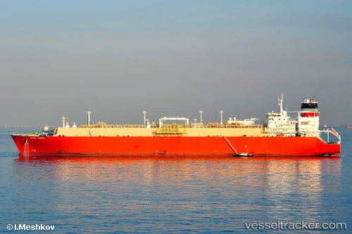
Vessel British Diamond IMO: 9333620, MMSI: 235060455 Lng Tanker

callsign: MIBR
size: 288x288

Live AIS position: UTC. Near OKPO), updated 2023-08-22 02:16:00 UTC.

Find the position of the vessel British Diamond on the map. The latter are known coordinates and path.

marine traffic ship tracker show on live map

The current position of vessel British Diamond is 34.85858 lat / 128.81056 lng. Updated: 2023-08-22 02:16:00 UTC

Currently sailing under the flag of United Kingdom

British Diamond built in 2008 year

Deadweight:
84553 t

Details:


Last coordinates of the vessel:
2023-08-22 02:16:00 UTC, 34.85858, 128.81056, course: 182, speed: 0


Most frequent ports a vessels calls at British Diamond (235060455):

Sambu, traffic: 4
Singapore, traffic: 3
Colon, traffic: 2
Cristobal, traffic: 2
Zamboanga, traffic: 2
Panama, traffic: 2
Balboa, traffic: 2
Strait Of Gibraltar, traffic: 1
Castro-Urdiales, traffic: 1
Urdiales, traffic: 1
Yokohama, traffic: 1
Yokosuka, traffic: 1
Gladstone Harbor, traffic: 1
Kawasaki, traffic: 1
Osaka, traffic: 1

Link to the map:


Find another ship

British_Diamond (235060455) last ports (portcalls and passsages)

Gladstone Harbor | 2023-07-15 02:02:16
Zamboanga | 2023-07-02 14:39:44
Singapore | 2023-05-01 05:18:54
Zamboanga | 2023-03-27 16:22:47
Urdiales | 2022-11-09 14:57:55
Strait Of Gibraltar | 2022-10-24 01:10:21
Bur Ibrahim | 2022-09-14 04:49:23
Yokosuka | 2022-08-10 04:15:03
Yokohama | 2022-08-09 01:21:44
Selat Lombok | 2022-07-11 16:52:41
Osaka | 2022-03-23 06:15:03
Panama | 2022-03-03 00:30:05
Balboa | 2022-03-02 20:50:09
Cristobal | 2022-03-02 12:15:11
Sambu | 2022-01-04 02:50:51
Singapore | 2022-01-04 02:35:30