 vesseltracker.com
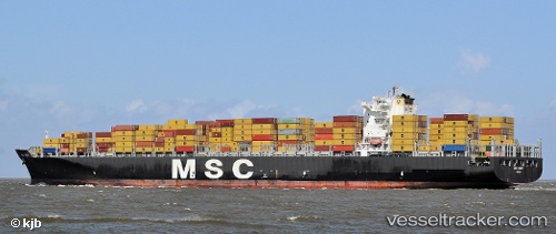
Vessel Msc Sindy IMO: 9336048, MMSI: 372736000 Container Ship
UTC, 40.51381, -58.99709, course: 265, speed: 18.1
UTC, 40.43167, -60.01833, course: -1, speed: 18
2026-02-06 11:52:48 UTC, 40.39167, -60.60833, course: -1, speed: 17
Live AIS position:
UTC. 278 nm SE of Bald Rock),
updated 2026-02-06 11:52:48 UTC.
Find the position of the vessel Msc Sindy on the map. The latter are known coordinates and path.
marine traffic ship tracker show on live map
The current position of vessel Msc Sindy is 40.39167 lat / -60.60833 lng. Updated: 2026-02-06 11:52:48 UTCCurrently sailing under the flag of Panama
Msc Sindy built in 2007 year
Deadweight:
117077 tDetails:
Last coordinates of the vessel:
UTC, 40.56333, -58.43667, course: -1, speed: 17UTC, 40.51381, -58.99709, course: 265, speed: 18.1
UTC, 40.43167, -60.01833, course: -1, speed: 18
2026-02-06 11:52:48 UTC, 40.39167, -60.60833, course: -1, speed: 17