 vesseltracker.com
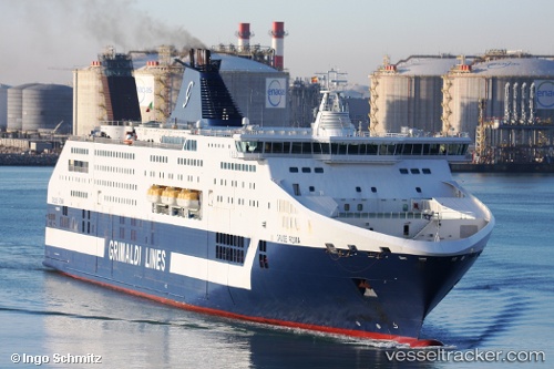
Vessel Cruise Roma IMO: 9351476, MMSI: 247219400 Passenger Ro Ro Cargo Ship
UTC, 41.36383, 2.17507, course: 30, speed: 0
UTC, 41.36383, 2.17507, course: 29, speed: 0
2026-02-01 07:33:01 UTC, 41.25417, 2.58734, course: 90, speed: 21.1
Live AIS position:
UTC. 17 nm SE of PREMIA DE MAR),
updated 2026-02-01 07:33:01 UTC.
Find the position of the vessel Cruise Roma on the map. The latter are known coordinates and path.
marine traffic ship tracker show on live map
The current position of vessel Cruise Roma is 41.25417 lat / 2.58734 lng. Updated: 2026-02-01 07:33:01 UTCCurrently sailing under the flag of Italy
Cruise Roma built in 2008 year
Deadweight:
7500 tDetails:
Last coordinates of the vessel:
UTC, 41.36384, 2.17508, course: 30, speed: 0UTC, 41.36383, 2.17507, course: 30, speed: 0
UTC, 41.36383, 2.17507, course: 29, speed: 0
2026-02-01 07:33:01 UTC, 41.25417, 2.58734, course: 90, speed: 21.1