.
vessel GAS ALYSSA IMO: 9364394, LPG Tanker vesseltracker.com
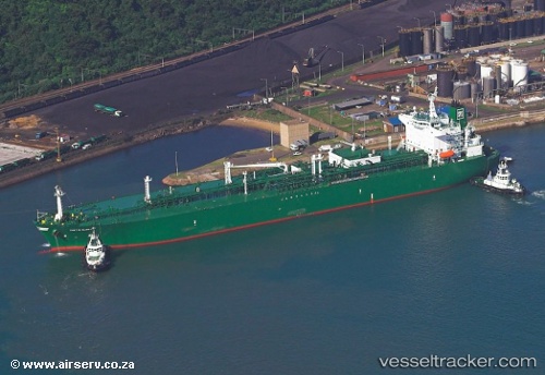
Vessel GAS ALYSSA IMO: 9364394, MMSI: 525401047 LPG Tanker

callsign: YDQU2
size: 36x226

Live AIS position: UTC. 87 nm N of Munshiganj), updated 2026-02-27 13:52:23 UTC.

Find the position of the vessel GAS ALYSSA on the map. The latter are known coordinates and path.

marine traffic ship tracker show on live map

The current position of vessel GAS ALYSSA is 24.90972 lat / -89.97863 lng. Updated: 2026-02-27 13:52:23 UTC

Currently sailing under the flag of Indonesia

GAS ALYSSA built in 2008 year

Deadweight:
54789 t

Details:


Last coordinates of the vessel:
UTC, 24.05816, -88.71711, course: -1, speed: 14.6
UTC, 24.33698, -89.14454, course: -1, speed: 14.8
UTC, 24.66541, -89.61125, course: -1, speed: 14.6
2026-02-27 13:52:23 UTC, 24.90972, -89.97863, course: -1, speed: 12.3


Most frequent ports a vessels calls at GAS ALYSSA (525401047):

Sambu, traffic: 19
Singapore, traffic: 13
JURONG ISLAND, traffic: 6
BUKOM ISLAND, traffic: 6
Tandjung Uban, traffic: 6
Sebang, traffic: 4
PULAU SAMBU, traffic: 4
SURALAYA, traffic: 3
TANAH MERAH, traffic: 3
BAKAUHENI, traffic: 3
Az Zarqa Island, traffic: 3
Umm Said, traffic: 2
Wu-Sung, traffic: 2
Wusong, traffic: 2
BATU AMPAR, traffic: 2

Link to the map:


Find another ship

GAS_ALYSSA (525401047) last ports (portcalls and passsages)

Sungai Udang Port | 2025-09-08 20:07:19
BUKOM ISLAND | 2025-09-05 07:33:50
JURONG ISLAND | 2025-09-01 08:08:26
JURONG ISLAND | 2025-08-28 07:23:16
JURONG ISLAND | 2025-08-24 06:05:58
JURONG ISLAND | 2025-08-20 05:31:01
BUKOM ISLAND | 2025-08-17 23:16:30
PULAU SAMBU | 2025-08-17 21:31:31
BATU AMPAR | 2025-08-17 21:03:55
PENGERANG | 2025-08-17 19:48:05
SURALAYA | 2025-08-08 11:24:21
BAKAUHENI | 2025-08-08 10:15:01
BUKOM ISLAND | 2025-05-10 21:55:49
PULAU SAMBU | 2025-05-10 21:10:53
TANAH MERAH | 2025-05-10 19:49:08
SURALAYA | 2025-05-03 18:20:07
SIR BANIYAS | 2025-04-20 06:32:42
Sebang | 2025-04-10 22:01:11
BUKOM ISLAND | 2025-04-06 09:54:36
PULAU SAMBU | 2025-04-06 08:25:24
PENGERANG | 2025-04-06 07:13:41
BAKAUHENI | 2025-03-26 18:42:03
Az Zarqa Island | 2025-03-12 22:43:34
CIWANDAN | 2025-02-26 18:13:23
SURALAYA | 2025-02-26 09:13:57
JURONG ISLAND | 2025-02-23 20:54:59
BUKOM ISLAND | 2025-02-23 19:22:34
PULAU SAMBU | 2025-02-23 18:49:23
TANAH MERAH | 2025-02-23 17:21:00
BAKAUHENI | 2025-02-21 18:51:14
Sebang | 2024-11-28 08:34:56
JURONG ISLAND | 2024-11-25 21:55:30
BUKOM ISLAND | 2024-11-25 20:01:44
TANAH MERAH | 2024-11-25 18:17:29
Az Zarqa Island | 2024-10-30 22:17:42
Sebang | 2024-10-21 17:06:59
Selat Lombok | 2024-10-10 17:52:54
Singapore | 2024-07-10 20:19:02
Selat Sunda | 2024-07-06 11:25:07
Panjang | 2024-07-06 08:34:55
Singapore | 2024-03-09 16:27:01
Az Zarqa Island | 2024-02-12 12:00:26
Singapore | 2024-02-01 23:43:56
Sambu | 2024-02-01 23:04:56
Sebang | 2023-10-03 08:04:33
Singapore | 2023-09-30 22:31:44
Sambu | 2023-09-30 21:42:29
Singapore | 2023-07-09 04:34:19
Tandjung Uban | 2023-07-08 00:30:11
Tandjung Uban | 2023-07-03 23:42:34
Sambu | 2023-06-03 00:43:57
Tandjung Uban | 2023-02-26 20:23:27
Tandjung Uban | 2023-02-22 17:05:20
Tandjung Uban | 2023-02-18 14:34:15
Mina Az Zawr | 2023-02-05 08:55:20
Mina Abd Allah | 2023-02-05 05:02:06
Tandjung Uban | 2023-01-21 05:29:43
Sambu | 2022-02-22 21:30:52
Wusong | 2022-02-11 06:03:33
Sambu | 2022-01-19 08:45:39
Singapore | 2022-01-19 08:35:38
Sirri Island | 2022-01-06 03:40:20
Singapore | 2021-12-27 01:25:07
Sambu | 2021-12-27 01:15:55
Nansha | 2021-12-20 05:06:40
Umm Said | 2021-12-01 12:10:00