 vesseltracker.com
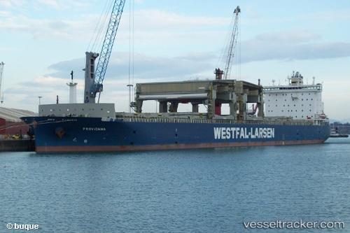
Vessel PROVIDANA IMO: 9380788, MMSI: 257515000 General Cargo Ship
UTC, 39.06121, 25.69952, course: -1, speed: 12.5
UTC, 38.68276, 25.71529, course: -1, speed: 12.6
2026-02-27 12:19:08 UTC, 38.25255, 25.71833, course: -1, speed: 12.1
Live AIS position:
UTC. 10 nm W of Mesta Hiou),
updated 2026-02-27 12:19:08 UTC.
Find the position of the vessel PROVIDANA on the map. The latter are known coordinates and path.
marine traffic ship tracker show on live map
The current position of vessel PROVIDANA is 38.25255 lat / 25.71833 lng. Updated: 2026-02-27 12:19:08 UTCCurrently sailing under the flag of Norway (NIS)
PROVIDANA built in 2007 year
Deadweight:
54810 tDetails:
Last coordinates of the vessel:
UTC, 39.55937, 25.73835, course: -1, speed: 12.3UTC, 39.06121, 25.69952, course: -1, speed: 12.5
UTC, 38.68276, 25.71529, course: -1, speed: 12.6
2026-02-27 12:19:08 UTC, 38.25255, 25.71833, course: -1, speed: 12.1