.
vessel Taurus IMO: 9403530, Bulk Carrier
vesseltracker.com
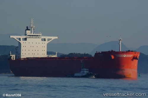
Vessel Taurus IMO: 9403530, MMSI: 235074621 Bulk Carrier

callsign: 2CPB4
size: 45x292

Live AIS position: UTC. Near Richards Bay), updated 2026-02-07 15:33:06 UTC.

Find the position of the vessel Taurus on the map. The latter are known coordinates and path.

marine traffic ship tracker show on live map

The current position of vessel Taurus is -28.97983 lat / 32.15325 lng. Updated: 2026-02-07 15:33:06 UTC
Details:


Last coordinates of the vessel:
UTC, -28.97833, 32.15167, course: -1, speed: 0
UTC, -28.97939, 32.15281, course: 41, speed: 0.2
UTC, -28.97973, 32.15309, course: 41, speed: 0.1
2026-02-07 15:33:06 UTC, -28.97983, 32.15325, course: 37, speed: 0.2


Most frequent ports a vessels calls at Taurus (235074621):

Selat Lombok, traffic: 11
Port Headland, traffic: 7
Port Hedland, traffic: 7
Samson Point, traffic: 6
Port Walcot, traffic: 6
Sambu, traffic: 6
TANAH MERAH, traffic: 4
PULAU SAMBU, traffic: 3
Singapore, traffic: 3
PENGERANG, traffic: 3
Dagu, traffic: 2
Maputo, traffic: 2
Rizhao, traffic: 2
Sriracha, traffic: 2
Bayuquan, traffic: 2

Link to the map:


Find another ship

Taurus (235074621) last ports (portcalls and passsages)

West Coast Town | 2025-09-14 11:41:22
Dung Quat Petroleum Port | 2025-08-09 00:07:57
DUNG QUAT | 2025-08-08 16:19:17
PENGERANG | 2025-08-04 21:02:19
BATU AMPAR | 2025-08-04 20:02:00
PANGKOR | 2025-08-01 08:47:30
PULAU SAMBU | 2025-07-31 03:12:18
TANAH MERAH | 2025-07-31 02:07:24
Taicang | 2025-04-15 19:19:08
Wusong | 2025-04-15 18:09:32
Jingjiang | 2025-04-15 12:16:55
PENGERANG | 2025-03-29 05:18:19
TANAH MERAH | 2025-03-29 04:02:10
PULAU SAMBU | 2025-03-29 02:54:46
Richards Bay | 2025-03-02 03:52:57
Maputo | 2025-02-28 23:08:03
Maputo | 2025-02-24 22:46:56
JURONG ISLAND | 2025-02-08 00:18:01
PULAU SAMBU | 2025-02-07 23:01:32
TANAH MERAH | 2025-02-06 11:58:42
PENGERANG | 2025-02-06 11:17:13
GUISHAN | 2024-12-31 13:01:50
Nansha | 2024-12-31 10:30:15
HUANGPU | 2024-12-29 05:18:52
DONG GUAN | 2024-12-29 03:30:06
Guangzhou | 2024-12-29 02:57:09
GUISHAN | 2024-12-25 09:37:41
Port Headland | 2024-12-11 20:51:04
Selat Lombok | 2024-12-07 07:29:43
JINGTANG | 2024-11-23 10:10:32
Selat Lombok | 2024-11-03 15:25:32
Port Headland | 2024-10-29 16:44:15
Rizhao | 2024-10-10 02:09:50
Selat Lombok | 2024-09-27 13:25:35
Port Headland | 2024-09-22 20:49:54
Bayuquan | 2024-08-31 17:43:32
Port Headland | 2024-08-13 08:57:05
Selat Lombok | 2024-08-08 23:36:05
Bayuquan | 2024-07-25 09:14:15
Lianyungang | 2024-07-19 19:04:17
Port Headland | 2024-07-03 17:11:10
Selat Lombok | 2024-05-27 18:27:49
Port Headland | 2024-05-23 03:09:43
Selat Lombok | 2024-05-17 18:13:24
Selat Lombok | 2024-04-22 08:50:13
Port Headland | 2024-04-18 03:26:42
Selat Lombok | 2024-04-12 00:59:44
Caldera | 2024-02-07 20:13:49
Tsugaru-Kaikyo | 2023-09-25 09:08:25
Rizhao | 2023-09-13 22:09:12
Sambu | 2023-05-28 10:28:21
Sriracha | 2023-05-22 10:09:51
Sriracha | 2023-05-18 10:04:32
Newcastle | 2023-04-27 22:47:21
Wusong | 2023-04-05 04:05:28
Saldanha Bay | 2023-02-18 05:12:47
Sambu | 2023-01-21 08:18:59
Ta-Ku | 2023-01-08 17:50:57
Ta-Ku | 2023-01-04 17:34:08
Taku Bar | 2023-01-04 14:46:47
Strait Of Gibraltar | 2022-09-18 01:03:37
Port Said | 2022-09-08 16:51:28
Bur Ibrahim | 2022-09-08 07:03:34
Ra’S Shukhayr | 2022-09-06 22:56:26
Selat Lombok | 2022-06-20 22:12:17
Samson Point | 2022-06-16 10:40:20
Samson Point | 2022-06-12 10:35:49
Samson Point | 2022-06-08 10:33:54
Samson Point | 2022-06-04 07:43:50
Samson Point | 2022-05-31 07:41:13
Samson Point | 2022-05-27 07:22:47
Selat Lombok | 2022-05-24 10:47:04