.
vessel '538009384' IMO: 9446441, vesseltracker.com
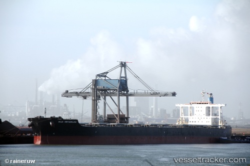
Vessel '538009384' IMO: 9446441, MMSI: 538009384

callsign:
size: x

Live AIS position: UTC. 198 nm NW of Port Mathurin), updated 2026-01-30 19:36:15 UTC.

Find the position of the vessel '538009384' on the map. The latter are known coordinates and path.

marine traffic ship tracker show on live map

The current position of vessel '538009384' is -17.31573 lat / 60.98500 lng. Updated: 2026-01-30 19:36:15 UTC
Details:


Last coordinates of the vessel:
UTC, -16.46941, 61.68638, course: 215, speed: 11.9
UTC, -16.62651, 61.55495, course: 214, speed: 12
UTC, -17.10600, 61.16308, course: 218, speed: 12.3
2026-01-30 19:36:15 UTC, -17.31573, 60.98500, course: 218, speed: 12.4


Most frequent ports a vessels calls at '538009384' (538009384):

La Coruna , traffic: 4
Sambu, traffic: 4
Taku Bar, traffic: 3
Sept Iles, traffic: 3
Sitrah Anchorage, traffic: 2
Sriracha, traffic: 2
Ta-Ku, traffic: 2
Dagu Bar, traffic: 2
Dagu, traffic: 2
Singapore, traffic: 2
Kali Limenes, traffic: 1
Las Palmas, traffic: 1
Pentland Firth, traffic: 1
Stadersand, traffic: 1
Pohang, traffic: 1

Link to the map:


Find another ship

'538009384' (538009384) last ports (portcalls and passsages)

Sitrah Anchorage | 2023-12-29 19:22:59
Sitrah Anchorage | 2023-12-25 18:52:02
Pohang | 2022-11-15 11:30:01
Ras Gharib | 2022-10-19 01:55:04
Bur Ibrahim | 2022-10-18 16:46:39
Port Said | 2022-10-18 07:04:27
Kali Limenes | 2022-10-16 01:38:30
Sept Iles | 2022-08-07 04:26:29
Sept Iles | 2022-08-03 02:03:32
Sept Iles | 2022-07-30 01:12:32
Pentland Firth | 2022-07-21 13:10:40
Stadersand | 2022-07-19 19:12:23
Calais | 2022-07-11 13:02:28
Dunkerque | 2022-07-08 22:22:09
La Coruna | 2022-07-04 16:59:30
La Coruna | 2022-06-30 16:36:23
Puerto De La Luz | 2022-06-25 16:04:02
Port Louis | 2022-05-29 01:16:48
Taku Bar | 2022-03-22 18:41:12
Ta-Ku | 2022-03-19 21:16:42
Taku Bar | 2022-03-19 19:06:11
Singapore | 2021-12-09 00:27:11
Sambu | 2021-12-09 00:17:04
Sriracha | 2021-12-01 01:01:22