 vesseltracker.com
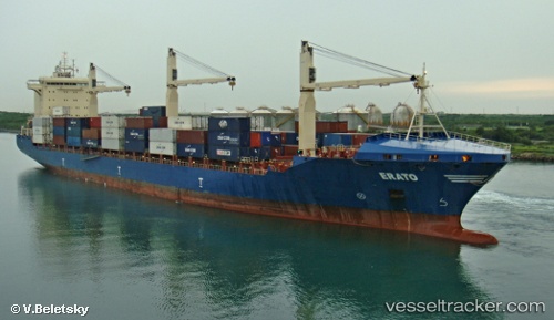
Vessel Erato IMO: 9472103, MMSI: 636015002 Container Ship
UTC, 19.55333, -82.89500, course: -1, speed: 17
UTC, 20.11167, -83.44500, course: -1, speed: 18
2026-02-26 18:24:47 UTC, 20.81333, -84.14667, course: -1, speed: 18
Live AIS position:
UTC. 75 nm S of San Julian),
updated 2026-02-26 18:24:47 UTC.
Find the position of the vessel Erato on the map. The latter are known coordinates and path.
marine traffic ship tracker show on live map
The current position of vessel Erato is 20.81333 lat / -84.14667 lng. Updated: 2026-02-26 18:24:47 UTCCurrently sailing under the flag of Liberia
Erato built in 2011 year
Deadweight:
34162 tDetails:
Last coordinates of the vessel:
UTC, 19.24333, -82.58833, course: -1, speed: 18UTC, 19.55333, -82.89500, course: -1, speed: 17
UTC, 20.11167, -83.44500, course: -1, speed: 18
2026-02-26 18:24:47 UTC, 20.81333, -84.14667, course: -1, speed: 18