 vesseltracker.com
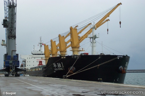
Vessel Hua Rong 1 IMO: 9650456, MMSI: 414119000 Bulk Carrier
UTC, 17.35123, 118.31100, course: 300, speed: 9.9
UTC, 17.42500, 118.15833, course: -1, speed: 10
2026-02-11 12:19:33 UTC, 17.66802, 117.65260, course: 295, speed: 9.8
Live AIS position:
UTC. 149 nm NW of Bolinao),
updated 2026-02-11 12:19:33 UTC.
Find the position of the vessel Hua Rong 1 on the map. The latter are known coordinates and path.
marine traffic ship tracker show on live map
The current position of vessel Hua Rong 1 is 17.66802 lat / 117.65260 lng. Updated: 2026-02-11 12:19:33 UTCCurrently sailing under the flag of China
Hua Rong 1 built in 2012 year
Deadweight:
56381 tDetails:
Last coordinates of the vessel:
UTC, 17.24183, 118.52888, course: 298, speed: 10.2UTC, 17.35123, 118.31100, course: 300, speed: 9.9
UTC, 17.42500, 118.15833, course: -1, speed: 10
2026-02-11 12:19:33 UTC, 17.66802, 117.65260, course: 295, speed: 9.8