 vesseltracker.com
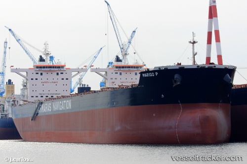
Vessel MARIGO P IMO: 9689706, MMSI: 636024610 Cargo
UTC, -11.24157, 115.98108, course: -1, speed: 10.1
UTC, -11.24157, 115.98108, course: -1, speed: 10.1
2026-03-04 23:44:42 UTC, -10.17500, 115.86833, course: -1, speed: 8
Live Vessel MARIGO P Analytics (details, animations, etc.)
Live AIS position: UTC. 81 nm S of Selat Lombok), updated 2026-03-04 23:44:42 UTC.Find the position of the vessel MARIGO P on the map. The latter are known coordinates and path.
marine traffic ship tracker show on live map
The current position of vessel MARIGO P is -10.17500 lat / 115.86833 lng. Updated: 2026-03-04 23:44:42 UTCCurrently sailing under the flag of Liberia
Details:
Last coordinates of the vessel:
UTC, -11.24157, 115.98108, course: -1, speed: 10.1UTC, -11.24157, 115.98108, course: -1, speed: 10.1
UTC, -11.24157, 115.98108, course: -1, speed: 10.1
2026-03-04 23:44:42 UTC, -10.17500, 115.86833, course: -1, speed: 8