 vesseltracker.com
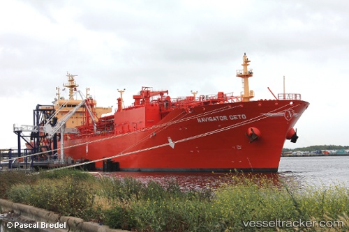
Vessel Navigator Ceto IMO: 9704532, MMSI: 636016660 Lpg Tanker
UTC, 52.92663, -150.06567, course: 68, speed: 8.2
UTC, 53.01681, -149.59152, course: 73, speed: 12.8
2026-02-16 08:30:26 UTC, 53.18421, -148.56117, course: 78, speed: 13.1
Live AIS position:
UTC. 31 nm NE of Kings Bromley),
updated 2026-02-16 08:30:26 UTC.
Find the position of the vessel Navigator Ceto on the map. The latter are known coordinates and path.
marine traffic ship tracker show on live map
The current position of vessel Navigator Ceto is 53.18421 lat / -148.56117 lng. Updated: 2026-02-16 08:30:26 UTCDetails:
Last coordinates of the vessel:
UTC, 52.85766, -150.43765, course: 66, speed: 8.3UTC, 52.92663, -150.06567, course: 68, speed: 8.2
UTC, 53.01681, -149.59152, course: 73, speed: 12.8
2026-02-16 08:30:26 UTC, 53.18421, -148.56117, course: 78, speed: 13.1