 vesseltracker.com
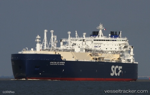
Vessel CHRISTOPHE DE MARGERIE IMO: 9737187, MMSI: 273261260 LNG Tanker
UTC, 70.99500, 73.81167, course: -1, speed: 0
UTC, 70.99417, 73.49262, course: 39, speed: 2.7
2026-03-06 19:40:59 UTC, 71.02833, 73.41667, course: -1, speed: 6
Live Vessel CHRISTOPHE DE MARGERIE Analytics (details, animations, etc.)
Live AIS position: UTC. Near Arctic SPG 2), updated 2026-03-06 19:40:59 UTC.Find the position of the vessel CHRISTOPHE DE MARGERIE on the map. The latter are known coordinates and path.
marine traffic ship tracker show on live map
The current position of vessel CHRISTOPHE DE MARGERIE is 71.02833 lat / 73.41667 lng. Updated: 2026-03-06 19:40:59 UTCCurrently sailing under the flag of Russia
CHRISTOPHE DE MARGERIE built in 2016 year
Deadweight:
96779 tDetails:
Last coordinates of the vessel:
UTC, 70.99333, 73.82333, course: -1, speed: 0UTC, 70.99500, 73.81167, course: -1, speed: 0
UTC, 70.99417, 73.49262, course: 39, speed: 2.7
2026-03-06 19:40:59 UTC, 71.02833, 73.41667, course: -1, speed: 6