 vesseltracker.com
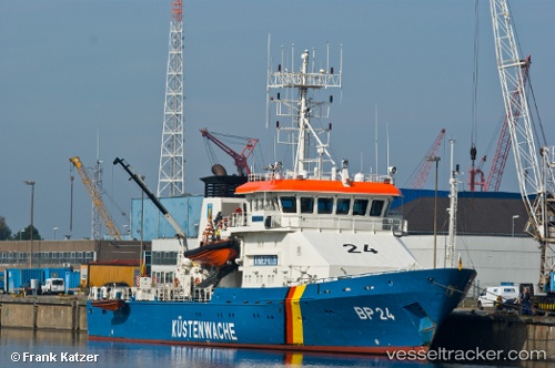
Vessel Bad Bramstedt IMO: 9252620, MMSI: 211383360 Pollution Control Vessel
UTC, 54.17505, 12.12057, course: 324, speed: 0.2
UTC, 54.17505, 12.12057, course: 324, speed: 0.2
2026-01-30 11:46:11 UTC, 54.17505, 12.12057, course: 324, speed: 0.2
Live AIS position:
UTC. Near Warnemunde),
updated 2026-01-30 11:46:11 UTC.
Find the position of the vessel Bad Bramstedt on the map. The latter are known coordinates and path.
marine traffic ship tracker show on live map
The current position of vessel Bad Bramstedt is 54.17505 lat / 12.12057 lng. Updated: 2026-01-30 11:46:11 UTCCurrently sailing under the flag of Germany
Bad Bramstedt built in 2002 year
Deadweight:
309 tDetails:
Last coordinates of the vessel:
UTC, 54.31595, 11.78782, course: 130, speed: 15.4UTC, 54.17505, 12.12057, course: 324, speed: 0.2
UTC, 54.17505, 12.12057, course: 324, speed: 0.2
2026-01-30 11:46:11 UTC, 54.17505, 12.12057, course: 324, speed: 0.2