 vesseltracker.com
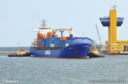
Vessel Aurette A IMO: 9242285, MMSI: 215413000 Container Ship
UTC, 11.8572, -15.5745, course: 213, speed: 0
UTC, 11.8572, -15.5745, course: 213, speed: 0
2026-02-20 21:51:11 UTC, 11.8572, -15.5745, course: 213, speed: 0
Live AIS position:
UTC. Near Bissau),
updated 2026-02-20 21:51:11 UTC.
Find the position of the vessel Aurette A on the map. The latter are known coordinates and path.
marine traffic ship tracker show on live map
The current position of vessel Aurette A is 11.8572 lat / -15.5745 lng. Updated: 2026-02-20 21:51:11 UTCCurrently sailing under the flag of Malta
Aurette A built in 2002 year
Deadweight:
17275 tDetails:
Last coordinates of the vessel:
UTC, 11.8572, -15.5745, course: 213, speed: 0UTC, 11.8572, -15.5745, course: 213, speed: 0
UTC, 11.8572, -15.5745, course: 213, speed: 0
2026-02-20 21:51:11 UTC, 11.8572, -15.5745, course: 213, speed: 0