 vesseltracker.com
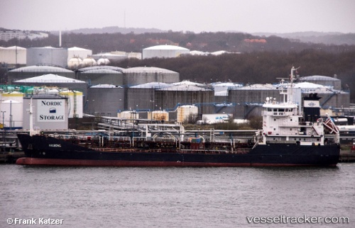
Vessel Aalborg IMO: 9327475, MMSI: 220609000 Chemical Oil Products Tanker
UTC, 36.12872, -5.40185, course: 178, speed: 6.9
UTC, 36.11030, -5.40317, course: 186, speed: 5.8
2026-01-17 05:47:42 UTC, 36.09680, -5.40960, course: 317, speed: 0.1
Live AIS position:
UTC. Near Algeciras),
updated 2026-01-17 05:47:42 UTC.
Find the position of the vessel Aalborg on the map. The latter are known coordinates and path.
marine traffic ship tracker show on live map
The current position of vessel Aalborg is 36.09680 lat / -5.40960 lng. Updated: 2026-01-17 05:47:42 UTCCurrently sailing under the flag of Denmark
Aalborg built in 2005 year
Deadweight:
3522 tDetails:
Last coordinates of the vessel:
UTC, 36.17190, -5.39453, course: 267, speed: 0.1UTC, 36.12872, -5.40185, course: 178, speed: 6.9
UTC, 36.11030, -5.40317, course: 186, speed: 5.8
2026-01-17 05:47:42 UTC, 36.09680, -5.40960, course: 317, speed: 0.1