 vesseltracker.com
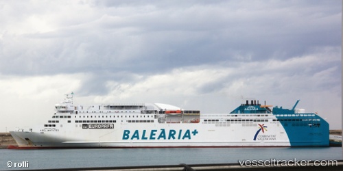
Vessel Abel Matutes IMO: 9441130, MMSI: 224402000 Passenger Ro Ro Cargo Ship
UTC, 41.19833, 2.23333, course: -1, speed: 19
UTC, 41.00268, 2.37635, course: -1, speed: 19
2026-03-01 22:50:33 UTC, 40.48167, 2.82667, course: -1, speed: 19
Live AIS position:
UTC. 16 nm S of Campredo),
updated 2026-03-01 22:50:33 UTC.
Find the position of the vessel Abel Matutes on the map. The latter are known coordinates and path.
marine traffic ship tracker show on live map
The current position of vessel Abel Matutes is 40.48167 lat / 2.82667 lng. Updated: 2026-03-01 22:50:33 UTCCurrently sailing under the flag of Spain
Abel Matutes built in 2010 year
Deadweight:
10863 tDetails:
Last coordinates of the vessel:
UTC, 41.34442, 2.17125, course: -1, speed: 0UTC, 41.19833, 2.23333, course: -1, speed: 19
UTC, 41.00268, 2.37635, course: -1, speed: 19
2026-03-01 22:50:33 UTC, 40.48167, 2.82667, course: -1, speed: 19